BLIZZARD WARNING REMAINS IN EFFECT FROM 7 PM WEDNESDAY TO 5 AM CT FRIDAY FOR THE FOLLOWING COUNTIES
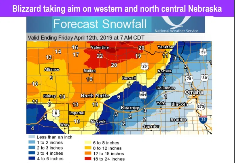
Eastern Cherry and Western Cherry, Keya Paha, Boyd, Brown, Rock, Holt, Blaine, Loup, Garfield, Wheeler, Custer, Greeley, Howard, Sherman and Valley Counties.
Greeley, Howard, Sherman and Valley Counties were added as of 4:00 pm Tuesday (4/9/19)
Blizzard conditions are likely with total snow accumulation of 4 to 11 inches and ice accumulation of around one tenth of an inch for parts of Loup-Garfield-Wheeler-Custer.
Snow accumulations for Eastern Cherry-Keya Paha-Western Cherry are trending anywhere from 11 to 19 inches and ice accumulations of around one tenth of an inch. Winds will gust as high as 60 mph.
For Boyd-Brown-Rock-Holt-Blaine, 9 to 15 inches and ice accumulations of around one tenth of an inch. Winds will gust as high as 60 mph.
Valley-Greeley-Sherman-Howard-Dawson-Buffalo-Gosper-Phelps-Furnas Counties could see accumulations of 3 to 6 inches locally up to 7 inches. ice accumulations of up to two tenths of an inch expected. North winds of 30 to 40 mph gusting as high as 50 to 60 mph.
Travel will be very difficult. Blowing snow will significantly reduce visibility. The hazardous conditions could impact the morning or evening commute. Strong winds could cause extensive damage to trees and power lines.
***WINTER STORM WATCH IN EFFECT FROM WEDNESDAY EVENING THROUGH FRIDAY MORNING***
Counties include: Antelope, Pierce, Boone, Dawson, Buffalo, Gosper, Phelps and Furnas.
Blizzard conditions are possible. Total snow accumulations of 3 to 6 inches and ice accumulations are trending higher in the central state counties of one to two tenths of an inch possible. Wind gusts as high as 55 to 60 mph.
Travel could be very difficult with areas of blowing snow significantly reducing visibility. Conditions may impact morning and evening commutes. Strong winds could cause extensive damage to trees and power lines, especially in areas that receive freezing rain.
CHECK 511 AS ROAD CLOSURES MAY BE POSSIBLE DURING THE BRUNT OF STORM.